Country: USA-NEW YORK
Features: BROOKLYN, UPPER BAY, FORT JAY
Center Coordinates: Lat. 40.6 Long. -74.0
Image Credit: NASA
Release Date: April 28, 2007
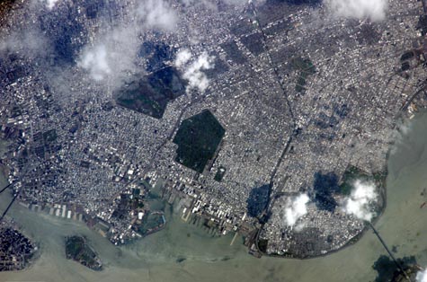
Brooklyn, New York
The Brooklyn, New York waterfront is featured in this image photographed by an Expedition 15 crewmember on the International Space Station. This view illustrates the dense urban fabric of Brooklyn, New York City's largest borough (population of 2.6 million), characterized by the regular pattern of highly reflective building rooftops (white). Two main arteries from Manhattan into Brooklyn, the famous Brooklyn Bridge and neighboring Manhattan Bridge, cross the East River along the left (north) side of the image. The dense built-up fabric contrasts with the
The original name for Brooklyn, Breukelen, means "broken land" in Dutch--perhaps in recognition of the highly mixed deposits (boulders, sand, silt, and clay) left behind by the Wisconsin glacier between 20,000--90,000 years ago, according to scientists. These deposits form much of Long Island, of which Brooklyn occupies the western tip. This image features one of Brooklyn's largest green spaces, the Green-Wood Cemetery. Today, the cemetery functions as both a natural park and a place of internment. The green tree canopy of the Cemetery contrasts sharply with the surrounding urban land cover, is an Audubon Sanctuary, and provides the final resting place for many 19th and 20th century New York celebrities. Also visible in the image is Governor's Island, which served as a strategic military installation for the US Army (1783--1966) and a major US Coast Guard installation (1966--1996). Today the historic fortifications on the island and their surroundings comprise the Governors Island National Monument.
Click Here