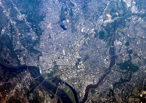
Astrophoto Lab
---your online source for astronomical and satellite images--- RETURN
Home
Welcome!
General Information
Special Galleries
AstroIndex
EarthIndex
Deep Space
Galaxies
Nebulae
Stars, Supernovae
Solar System
Earth from Space
NASA Space Programs
Other Astro Images
Posters
Space Image Gallery
Useful Links
Credits & Useage
Feedback
Signup
Satellite: International Space Station
Location: USA-DC
Features: WASHINGTON METRO AREA
Center Coordinates: Lat. 38.9 Long. -77.0
Image Credit: NASA
Release Date: May 2, 2006
Washington, D.C.

George Washington not only served as the namesake for the capital city of the United States, he also chose its location, perhaps envisioning the transportation possibilities that the Potomac River flowing past the site would provide. Early on, the city saw conflict; in the War of 1812, British forces invaded and burned several public buildings. The Civil War marked the beginning of the city's transformation from a provincial town to a world center of culture, history, and political energy during the 20th century. According to the Census Bureau, the District of Columbia, which comprises the city of Washington, supported a population of more than half a million inhabitants in 2003.

This picture was taken as the International Space Station passed over the western border of Maryland and West Virginia. The resolution and spatial coverage of this image are similar to the 15-meter-per-pixel data obtained by sensors onboard the Landsat 7 and Terra satellites. Recognizable in this image are the Capitol Building, the Washington Monument (and its shadow), and the Lincoln Memorial, along the northeast bank of the Potomac River
Buy a Print
Click Here