Image Credit: NASA/USGS
Release Date: November 5, 2010
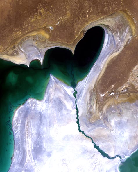
Heart of Central Asia
This Landsat image features the heart-shaped northern tip of the western half of the Large Aral Sea (or South Aral Sea) in Central Asia. Previously one of the four largest lakes in the world with an area of 68,000 square kilometers (26,300 sq mi), the Aral Sea has been steadily shrinking since the 1960s after the rivers that fed it were diverted by Soviet irrigation projects
By the end of the 1980s, so little water was reaching the lake, it split into two sections: the Small Aral Sea (not visible) in Kazakhstan and the Large Aral Sea shared by Kazakhstan and Uzbekistan. By 2000, the Large Aral Sea had split into two - an eastern and western lobe. By 2007, it had declined to 10% of its original size, splitting into four lakes - the North Aral Sea, the eastern and western basins of the once far larger South Aral Sea and one smaller lake between North and South Aral Seas. By 2009, the southeastern lake had disappeared and the southwestern lake retreated to a thin strip at the extreme west of the former southern sea. The maximum depth of the North Aral Sea is 42 m (138 ft) (as of 2008).
In an ongoing effort in Kazakhstan to save and replenish the North Aral Sea, a dam was built in 2005 between the sea's northern and southern sections to help improve water resource management and reverse the man-made environmental disaster. The dam allowed the river to feed the northern Aral, which has begun to recover. By 2008,
Click Here
the water level in this lake had risen by 24 m (79 ft) from its lowest level in 2007. Salinity has dropped, and fish are again found in sufficient numbers for some fishing to be viable. It didn't solve the entire problem though, as the southern section is expected to dry out completely by 2020.
The whitish area surrounding the lakebed is a vast salt plain, now called the Aralkum Desert, left behind by the evaporating sea. It comprises some 40 000 sq km zone of dry, white salt and mineral terrain. Each year violent sandstorms pick up at least 150,000 tons of salt and sand from Aralkum and transport them across hundreds of kilometers, causing severe health problems for the local population and making regional winters colder and summers hotter.
The shrinking of the Aral Sea has been called "one of the planet's worst environmental disasters." The region's once prosperous fishing industry has been essentially destroyed, bringing unemployment and economic hardship. The Aral Sea region is also heavily polluted, with consequent serious public health problems. The retreat of the sea has reportedly also caused local climate change, with summers becoming hotter and drier, and winters colder and longer.
The Thematic Mapper on Landsat 5, jointly managed by NASA and the US Geological Survey, acquired this image on 24 July 2010. ESA supports the Landsat series as a Third Party Mission, meaning it uses its ground infrastructure and expertise to acquire, process and distribute Landsat data to users