Instrument: HRVIR
Center coordinates: lat. 55.70, long. 12.55
Image Credit: ESA, CNES, Spot Image
Release Date: Jan 1, 2004
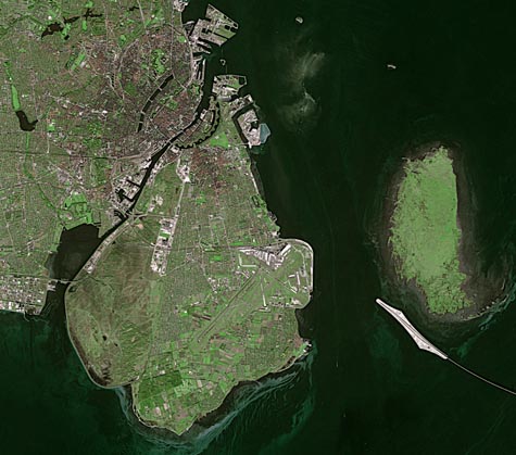
Copenhagen, Denmark
Copenhagen, the capital
of Denmark, is highlighted in this image. The largest city in Denmark,
Copenhagen is located on the eastern side of the island of Zealand (left)
and on the island of Amager (right). First founded as a fishing village
around a thousand years ago, Copenhagen has subsequently grown in economic
significance as a consequence of its natural harbor facing the Øresund
Strait (The Sound), which divides Denmark from Sweden and links the Baltic
to the North Sea. The island visible east of Amager is Saltholm, translated
as ‘Salt Islet’. The white structure southwest of Saltholm is
the artificial island of Peberholm, translated as ‘Pepper Islet’.
Peberholm was created as part of the Øresund Bridge, a combined
two-track rail and four-lane road bridge-tunnel across the Øresund
Strait that connects Copenhagen with the Swedish city of Malmö (not
visible). Peberholm serves as a crossover point between the bridge,
Click Here
The Copenhagen-Malmö Port stretches 10 km between Zealand and Amager and 7 km along the Sound. Adjacent to the modern port facilities a star-shaped fortification, known as Kastellet, can be seen. A relic of Copenhagen’s past, this fortress is more than 340 years old. Trace the coast of Zealand westward to find an area of land enclosed by an inverted-U. This is the small island of Slotsholmen, which is the location of Christiansborg Palace, home to Denmark’s Folketing or Parliament and also the Danish Royal Library.
Since 2000, this historic city has also been home to one of the largest offshore wind farms ever built, the Middelgrunden Offshore Wind Farm (visible). It is situated on a natural reef about 3.5 km east of Copenhagen harbor.
Anchored in concrete foundations, the wind farm's 20 turbines are positioned in an arc measuring 3.4 km in length. The farm produces 89 000 megawatts of electricity annually, enough to supply upwards of 3% of Copenhagen’s needs. Denmark has been supporting wind power through tax incentives and subsidies since the 1970s. By 2040 Denmark plans to meet 40% of its electricity needs using wind energy, up from a figure of 13% in 2001. Copenhagen Airport is visible as an L-shaped, white structure on the eastern side of Amager.