Instrument: MERIS
Center coordinates: lat. 24.81, long. 55.76
Image Credit: ESA
Release Date: February 4, 2011
Middle
Eastern Terrain: Dubai area
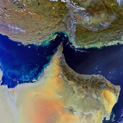
The south-eastern parts of Iran (top) and the Arabian Peninsula are featured in this Envisat image. Iran's landscape, comprising several rugged mountain ranges, a central high plateau, deserts, steppes and coastlands, differs from the Arabian Peninsula, which is dominated by the Arabian Desert.
The closest point between the two Middle Eastern countries is the Strait of Hormuz (center), which links the Persian Gulf (left) with the Gulf of Oman (upper right) and the Arabian Sea (lower right). The ridges, dissected uplands and depressions of the Hormozgan province are visible in Iran. Qeshm Island (parallel to the coast) is Iran's largest island. Green and tan swirls along the country's coastline are due to sediments being transported in the water.
Several countries are visible on the peninsula: the United Arab Emirates (top left), Oman (tip and bottom right) and Saudi Arabia (far left and bottom). Oman's only
Click Here
Dubai's manmade islands off the coast of the United Arab Emirates are surrounded by swirls of plankton and sediments. The relatively shallow depth of the Persian Gulf and the wide continental shelf off the Dubai coast made the construction of these artificial islands possible